Exemples et extraits de code
WMS avec OpenLayers
Cet exemple montre l’utilisation du service WFS avec les bornes vélo’v en temps réel à travers la bibliothèque OpenLayers.
Code source correspondant :
<html>
<head>
<title>Utilisation des services GrandLyon Data : OpenLayers</title>
<script src="http://openlayers.org/api/OpenLayers.js"></script>
</head>
<body>
<div style="width:100%; height:100%" id="map"></div>
<script defer="defer" type="text/javascript">
var map = new OpenLayers.Map('map');
var osm = new OpenLayers.Layer.OSM('Simple OSM Map', null, {
//conversion en valeurs de gris à la volée
eventListeners: {
tileloaded: function(evt) {
var ctx = evt.tile.getCanvasContext();
if (ctx) {
var imgd = ctx.getImageData(0, 0, evt.tile.size.w, evt.tile.size.h);
var pix = imgd.data;
for (var i = 0, n = pix.length; i < n; i += 4) {
pix[i] = pix[i + 1] = pix[i + 2] = (3 * pix[i] + 4 * pix[i + 1] + pix[i + 2]) / 8;
}
ctx.putImageData(imgd, 0, 0);
evt.tile.imgDiv.removeAttribute("crossorigin");
evt.tile.imgDiv.src = ctx.canvas.toDataURL();
}
}
}
});
//URL du service data
var data_url = "https://data.grandlyon.com/geoserver/wfs?";
//Définition du proxy pour gérer le cross-domain. Voir le paragraphe Bonne Pratiques -> Proxyfication pour plus d'information
OpenLayers.ProxyHost = "/cgi-bin/proxy.cgi?url=";
//Styles pour le rendu
var colors = ["green", "blue", "orange", "grey"];
var context = {
getColor: function(feature) {
return colors[feature.data.availabilitycode - 1];
}
}
var template = {
pointRadius: 15,
fillColor: "${getColor}" // using context.getColor(feature)
};
var style = new OpenLayers.Style(template, {context: context});
//Définition du layer WFS
var wfs = new OpenLayers.Layer.Vector("WFS GL Data", {
strategies: [new OpenLayers.Strategy.BBOX()],
protocol: new OpenLayers.Protocol.WFS({
version: "1.1.0",
srsName: "EPSG:4326",
url: data_url,
featurePrefix : 'ms',
featureType: "jcd_jcdecaux.jcdvelov",
geometryName: "msGeometry",
formatOptions: {
xy: false
}
}),
styleMap: new OpenLayers.StyleMap(style),
renderers: OpenLayers.Layer.Vector.prototype.renderers
});
//gestion du click sur les markers
var selectControl = new OpenLayers.Control.SelectFeature(wfs);
map.addControl(selectControl);
selectControl.activate();
wfs.events.on({
featureselected: function(event) {
var feature = event.feature;
feature.popup = new OpenLayers.Popup.FramedCloud("box",
feature.geometry.getBounds().getCenterLonLat(),
null,
'<div><b>'+feature.data.name + '</b> (station '+feature.data.number+')<br/>'
+ 'Il reste <b>' + feature.data.available_bikes + '</b> vélos disponibles et '
+ '<b>' + feature.data.available_bike_stands + ' </b>bornes libres</div>',
null,
true
);
while( map.popups.length ) {
map.removePopup( map.popups[0] );
}
map.addPopup(feature.popup);
}
});
//Config de la map
map.addLayers([osm, wfs]);
var zoom = 15;
var lonLat = new OpenLayers.LonLat(4.85,45.76);
map.setCenter(
lonLat.transform(
new OpenLayers.Projection("EPSG:4326"),
map.getProjectionObject()
), zoom
);
</script>
</body>
</html>
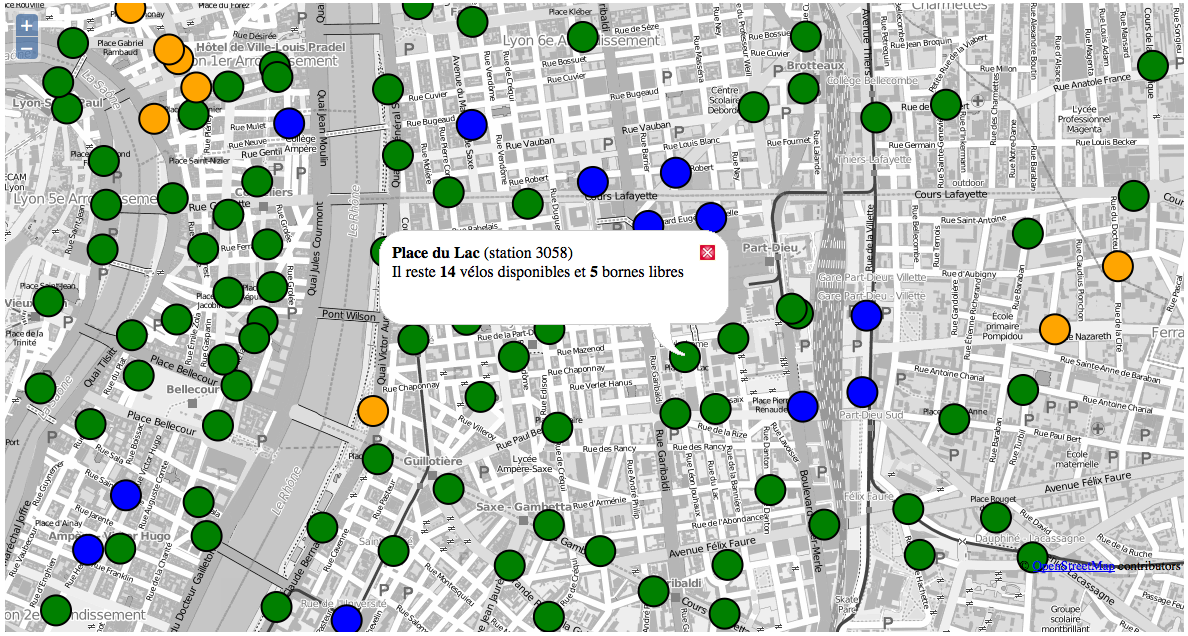
WFS avec Leaflet
Cet exemple montre l’utilisation du service WFS avec les bornes vélo’v en temps réel à travers la bibliothèque LeafLet.
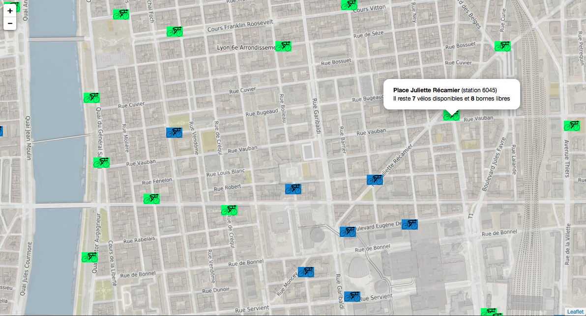
Code source correspondant :
<html>
<head>
<title>Utilisation des services GrandLyon Data : Leaflet</title>
<meta charset="utf-8" />
<meta name="viewport" content="width=device-width, initial-scale=1.0">
<script src="http://code.jquery.com/jquery-1.10.2.min.js"></script>
<script src="https://unpkg.com/leaflet@1.0.1/dist/leaflet.js"></script>
<link rel="stylesheet" href="https://unpkg.com/leaflet@1.0.1/dist/leaflet.css" />
<link rel="stylesheet" href="leaflet.css" />
<style>
body {
padding: 0;
margin: 0;
}
html, body, #map {
height: 100%;
}
</style>
</head>
<body>
<div id="map"></div>
<script>
//Initialisation de la map
var map = L.map('map').setView([45.76, 4.85], 14);
//Layer WMS sur une orthophoto
L.tileLayer.wms("https://data.grandlyon.com/geoserver/wms",{
layers: '1840_5175_16_CC46',
format: 'image/png',
transparent: true,
opacity: 0.6
}).addTo(map);
//Layer WMS openstreetmap
L.tileLayer.wms("https://openstreetmap.data.grandlyon.com/",{
layers: 'osm_grandlyon',
format: 'image/png',
transparent: true,
opacity: 0.7
}).addTo(map);
//Définition du proxy pour le WFS (cross domain). Voir le paragraphe Bonne Pratiques -> Proxyfication pour plus d'information
var proxy = "proxy.php?url=";
var data_url = "https://data.grandlyon.com/geoserver/wfs";
var params = '?SERVICE=WFS
&REQUEST=GetFeature
&VERSION=1.1.0
&TYPENAME=jcd_jcdecaux.jcdvelov
&outputformat=geojson';
var VertIcon = L.icon({
iconUrl: 'images/cycling_Vert.png',
iconSize: [33, 21]
});
var OrangeIcon = L.icon({
iconUrl: 'images/cycling_Orange.png',
iconSize: [33, 21]
});
var BleuIcon = L.icon({
iconUrl: 'images/cycling_Bleu.png',
iconSize: [33, 21]
});
var GrisIcon = L.icon({
iconUrl: 'images/cycling_Gris.png',
iconSize: [33, 21]
});
$.get(proxy + encodeURIComponent(data_url + params), function(json){
var obj = $.parseJSON(json);
// Add markers
for(i=0;i<obj.features.length;i++) {
//create feature from json
var ftr = obj.features[i];
// set marker options from properties
var options = {
gid: ftr.properties.gid,
number: ftr.properties.number,
name: ftr.properties.name,
available_bikes: ftr.properties.available_bikes,
available_bike_stands: ftr.properties.available_bike_stands
};
//set marker icon from availability
switch(ftr.properties.availability){
case 'Vert':
options.icon = VertIcon;
break;
case 'Orange':
options.icon = OrangeIcon;
break;
case 'Bleu' :
options.icon = BleuIcon;
break;
default :
options.icon = GrisIcon;
}
//ajout du marker à la map
var point = L.marker(
[ftr.geometry.coordinates[1],ftr.geometry.coordinates[0]],
options
).addTo(map);
//définition de la popup sur le click
point.bindPopup(
'<b>'+ point.options.name + '</b> (station '+point.options.number+')<br/>'
+ 'Il reste <b>' + point.options.available_bikes + '</b> vélos disponibles'
+ ' et <b>' + point.options.available_bike_stands + ' </b>bornes libres',
{
closeButton: false
}
);
}
});
</script>
</body>
</html>
KML avec l’API Maps de Google
Cet exemple montre l’utilisation du service KML avec les bornes vélo’v à travers l’API Google Maps v3. Nécessite une clé pour l’API.
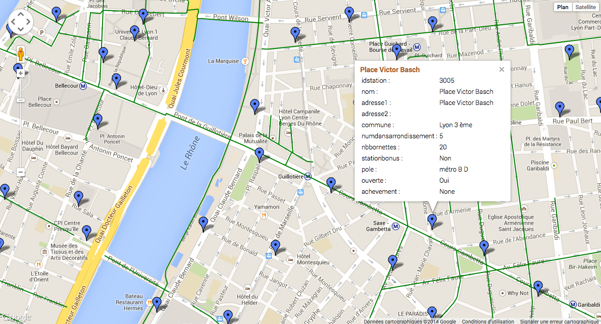
Code source correspondant :
<html>
  <head>
    <title>Utilisation des services GrandLyon Data : Google API</title>
    <meta name="viewport" content="initial-scale=1.0, user-scalable=no" />
    <style type="text/css">
      html { height: 100% }
      body { height: 100%; margin: 0; padding: 0 }
      #map-canvas { height: 100% }
    </style>
    <script type="text/javascript"
        src="https://maps.googleapis.com/maps/api/js?key=API_KEY&sensor=false">
    </script>

    <script type="text/javascript">
      function initialize() {
        //Init map
        var mapOptions = {
          center: new google.maps.LatLng(45.76, 4.85),
          zoom: 13
        };
        var map = new google.maps.Map(document.getElementById("map-canvas"),
            mapOptions);

        //Ajout WMS sur l'aménagement cyclable
        var urlWMS = "https://data.grandlyon.com/geoserver/wms?"
                + "&REQUEST=GetMap&SERVICE=WMS&VERSION=1.3.0&CRS=EPSG:4171"
                + "&LAYERS=pvo_patrimoine_voirie.pvoamenagementcyclable"
                + "&FORMAT=image/png&TRANSPARENT=TRUE&WIDTH=256&HEIGHT=256";
        //L'API Google Map ne gère pas directement le WMS, il faut passer par un ImageMapType
        var WMS_Layer = new google.maps.ImageMapType({
            getTileUrl: function (coord, zoom) {
                var projection = map.getProjection();
                var zoomfactor = Math.pow(2, zoom);
                var LL_upperleft = projection.fromPointToLatLng(
                    new google.maps.Point(
                        coord.x * 256 / zoomfactor,
                        coord.y * 256 / zoomfactor
                    )
                );
                var LL_lowerRight = projection.fromPointToLatLng(
                    new google.maps.Point(
                        (coord.x + 1) * 256 / zoomfactor,
                        (coord.y + 1) * 256 / zoomfactor
                    )
                );
                var bbox =  "&bbox="
                    + LL_lowerRight.lat() + "," + LL_upperleft.lng() + ","
                    + LL_upperleft.lat() + "," + LL_lowerRight.lng();
                var url = urlWMS + bbox;
                return url;
            },
            tileSize: new google.maps.Size(256, 256),
            isPng: true
        });

        map.overlayMapTypes.push(WMS_Layer);

        //Ajout KML layer
        var KML_Layer = new google.maps.KmlLayer({
          url: 'https://data.grandlyon.com/geoserver/wms?'
            +'format=KML&request=layer&typename=pvo_patrimoine_voirie.pvostationvelov'
        });
        KML_Layer.setMap(map);

      }
      google.maps.event.addDomListener(window, 'load', initialize);
    </script>

  </head>
  <body>
    <div id="map-canvas"/>
  </body>
</html>
Utilisation du WCS
Cet exemple montre l’utilisation du service WCS pour obtenir les données brutes sur le NO2 en 2012. Nous utiliserons dans ces exemples la version 2.0.1 qui est la plus récente. Il est encore possible d’utiliser aussi les versions 1.1.1 ou 1.0.0. Etape 1 : lecture des capacités du service https://data.grandlyon.com/wcs/rdata?SERVICE=WCS&REQUEST=GetCapabilities&VERSION=2.0.1 .. image:: _static/wcs_GetCapabilities.png Parmi les informations retournées, on peut consulter les formats de sortie disponibles. Le WCS est un service destiné à fournir de la donnée brute (raw data). Il est donc recommandé de l’utiliser avec un format comme image/x-aaigrid pour un raster monobande ou image/tiff pour un raster multibandes, plutôt qu’avec un des formats de sortie prévus pour la visualisation, comme image/jpeg ou image/gif. Dans la dernière partie du XML renvoyé, on trouve la liste des couvertures disponibles pour ce service, dont la couverture grandlyon:STFONS_Step_02cm_2018, que nous utiliserons dans la suite de l’exemple.
Etape 2 : détail d’une couverture https://data.grandlyon.com/geoserver/wcs?SERVICE=WCS&REQUEST=DescribeCoverage&VERSION=2.0.1&COVERAGEID=grandlyon:STFONS_Step_02cm_2018 Attention, en version 2.0.1, le paramètre pour indiquer la couverture demandée est COVERAGEID, mais en version 1.0 c’est IDENTIFIER et en version 1.1, c’est COVERAGE. Attention également à la casse dans le nom de la couverture demandée si vous testez manuellement les requêtes : le service WCS y est sensible. Ainsi la couverture grandlyon:sTFONS_Step_02cm_2018 (avec un s minuscule ) ne sera pas trouvée. .. image:: _static/wcs_DescribeCoverage.png Cette requête permet d’obtenir tous les détails de la couverture comme son étendue géographique ou des informations sur les bandes. On voit ainsi dans notre cas qu’il s’agit d’images multi-canaux à 3 bandes.
Etape 3 : obtention de la couverture La requête suivante permet d’obtenir le raster au format TIFF : https://data.grandlyon.com/geoserver/wcs?SERVICE=WCS&VERSION=2.0.1&REQUEST=GetCoverage&FORMAT=image/tiff&COVERAGEID=grandlyon:STFONS_Step_02cm_2018
Utilisation du service CSW
Cet exemple montre l’utilisation du service CSW pour obtenir des informations sur les métadonnées.
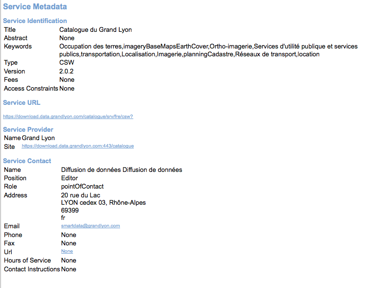
Etape 1 : lecture des capacités du service
https://data.grandlyon.com/geonetwork/srv/fre/csw?version=2.0.2&request=GetCapabilities&service=CSW
Exemple de présentation du XML reçu (plugin CSW dans QGIS) :
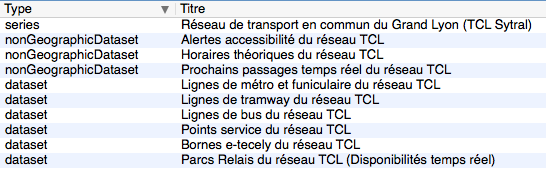
Etape 2 : recherche sur des mots clés (Réseaux de transport)
Requête POST : https://data.grandlyon.com/geonetwork/srv/fre/csw avec dans le data du POST :
<?xml version="1.0" ?>
<csw:GetRecords maxRecords="10" outputFormat="application/xml" outputSchema="http://www.opengis.net/cat/csw/2.0.2" resultType="results" service="CSW" version="2.0.2" xmlns:csw="http://www.opengis.net/cat/csw/2.0.2" xmlns:ogc="http://www.opengis.net/ogc" xmlns:xsi="http://www.w3.org/2001/XMLSchema-instance" xsi:schemaLocation="http://www.opengis.net/cat/csw/2.0.2 http://schemas.opengis.net/csw/2.0.2/CSW-discovery.xsd">
        <csw:Query typeNames="csw:Record">
                <csw:ElementSetName>full</csw:ElementSetName>
                <csw:Constraint version="1.1.0">
                        <ogc:Filter>
                                <ogc:PropertyIsLike escapeChar="\" singleChar="_" wildCard="%">
                                        <ogc:PropertyName>csw:AnyText</ogc:PropertyName>
                                        <ogc:Literal>Réseaux de transport</ogc:Literal>
                                </ogc:PropertyIsLike>
                        </ogc:Filter>
                </csw:Constraint>
        </csw:Query>
</csw:GetRecords>
Extrait du XML obtenu en retour :
<?xml version="1.0" encoding="UTF-8"?>
<csw:GetRecordsResponse xmlns:csw="http://www.opengis.net/cat/csw/2.0.2" xmlns:xsi="http://www.w3.org/2001/XMLSchema-instance" xsi:schemaLocation="http://www.opengis.net/cat/csw/2.0.2 http://schemas.opengis.net/csw/2.0.2/CSW-discovery.xsd">
<csw:SearchStatus timestamp="2015-11-06T16:36:24" />
<csw:SearchResults numberOfRecordsMatched="47" numberOfRecordsReturned="10" elementSet="full" nextRecord="11">
<csw:Record xmlns:ows="http://www.opengis.net/ows" xmlns:geonet="http://www.fao.org/geonetwork" xmlns:dc="http://purl.org/dc/elements/1.1/">
<dc:title xmlns:dct="http://purl.org/dc/terms/">Alertes accessibilité du réseau TCL</dc:title>
<dc:creator xmlns:dct="http://purl.org/dc/terms/">256900994</dc:creator>
<dc:subject xmlns:dct="http://purl.org/dc/terms/">Réseaux de transport</dc:subject>
<dc:subject xmlns:dct="http://purl.org/dc/terms/">Services d'utilité publique et services publics</dc:subject>
<dc:description xmlns:dct="http://purl.org/dc/terms/">Les alertes accessibilité recensent les ascenseurs et escaliers mécaniques actuellement indisponibles dans les stations de métro et de tramway équipées du réseau TCL.</dc:description>
<dc:publisher xmlns:dct="http://purl.org/dc/terms/">SYTRAL</dc:publisher>
<dc:type xmlns:dct="http://purl.org/dc/terms/">nonGeographicDataset</dc:type>
<dc:format xmlns:dct="http://purl.org/dc/terms/">application/json</dc:format>
<dc:format xmlns:dct="http://purl.org/dc/terms/">text/csv</dc:format>
<dc:format xmlns:dct="http://purl.org/dc/terms/">csv (taille : 2 Ko)</dc:format>
<dc:source xmlns:dct="http://purl.org/dc/terms/">Données provenant de la base géographique et topologique TCL SYTRAL.</dc:source>
<dc:language xmlns:dct="http://purl.org/dc/terms/">fre</dc:language>
<dc:relation xmlns:dct="http://purl.org/dc/terms/">https://download.data.grandlyon.com/ws/rdata/tcl_sytral.tclalerteaccessibilite/all.json</dc:relation>
<dc:relation xmlns:dct="http://purl.org/dc/terms/">https://download.data.grandlyon.com/files/rdata/tcl_sytral.tclalerteaccessibilite/alerte_accessibilite.csv</dc:relation>
<dc:relation xmlns:dct="http://purl.org/dc/terms/">https://download.data.grandlyon.com/files/grandlyon/LicenceEngagee.pdf</dc:relation>
<dc:coverage xmlns:dct="http://purl.org/dc/terms/">North 45.917, South 45.55, East 5.067, West 4.681. GRAND LYON</dc:coverage>
<dc:rights xmlns:dct="http://purl.org/dc/terms/">Licence Engagée</dc:rights>
<dc:rights xmlns:dct="http://purl.org/dc/terms/">Pas de restriction d'accès public selon INSPIRE</dc:rights>
<dct:created xmlns:dct="http://purl.org/dc/terms/">2014-12-04</dct:created>
<dct:dateSubmitted xmlns:dct="http://purl.org/dc/terms/">2015-02-02</dct:dateSubmitted>
<dct:isPartOf xmlns:dct="http://purl.org/dc/terms/">16a9a657-e938-484e-a067-5cdacd7a0419</dct:isPartOf>
<dct:accessRights xmlns:dct="http://purl.org/dc/terms/">Free access with registration</dct:accessRights>
<dct:accrualPeriodicity xmlns:dct="http://purl.org/dc/terms/">continuous</dct:accrualPeriodicity>
<dct:modified xmlns:dct="http://purl.org/dc/terms/">2015-11-06T00:02:26</dct:modified>
<dc:identifier xmlns:dct="http://purl.org/dc/terms/">4721ec9e-86c8-4687-8713-f406290949ad</dc:identifier>
<ows:BoundingBox crs="urn:x-ogc:def:crs:EPSG:6.11:4326">
<ows:LowerCorner>45.55 4.681</ows:LowerCorner>
<ows:UpperCorner>45.917 5.067</ows:UpperCorner>
</ows:BoundingBox>
</csw:Record>
<csw:Record xmlns:ows="http://www.opengis.net/ows" xmlns:geonet="http://www.fao.org/geonetwork" xmlns:dc="http://purl.org/dc/elements/1.1/" xmlns:dct="http://purl.org/dc/terms/">
<dc:identifier>58f93af3-a651-4cbd-bd9d-b4562f8d404d</dc:identifier>
<dc:date>2015-11-06T00:04:55</dc:date>
<dc:title>Lignes de métro et funiculaire du réseau TCL</dc:title>
<dc:type>dataset</dc:type>
<dc:subject>Réseaux de transport</dc:subject>
<dc:subject>Services d'utilité publique et services publics</dc:subject>
<dc:subject>transportation</dc:subject>
<dc:format />
<dct:abstract>La représentation graphique des lignes de métro et de funiculaire du réseau TCL est un objet linéaire qui localise la ligne et son parcours de terminus à terminus.
La représentation graphique des lignes est caractérisée par des informations de gestion (identifiant, numéro de ligne et sens, libellé, unité de transport, couleur du tracé, famille de transport) et de tracés (polylignes de terminus à terminus).</dct:abstract>
<dc:description>La représentation graphique des lignes de métro et de funiculaire du réseau TCL est un objet linéaire qui localise la ligne et son parcours de terminus à terminus.
La représentation graphique des lignes est caractérisée par des informations de gestion (identifiant, numéro de ligne et sens, libellé, unité de transport, couleur du tracé, famille de transport) et de tracés (polylignes de terminus à terminus).</dc:description>
<dc:rights>license</dc:rights>
<dc:language>fre</dc:language>
<dc:source>Données provenant de la base géographique et topologique TCL SYTRAL.</dc:source>
<dc:relation>16a9a657-e938-484e-a067-5cdacd7a0419</dc:relation>
<dc:format />
<ows:BoundingBox crs="urn:ogc:def:crs:EPSG::RGF93 / CC46 (EPSG:3946)">
<ows:LowerCorner>5.1410943067093 45.486705557736</ows:LowerCorner>
<ows:UpperCorner>4.629545313738 45.945335689366</ows:UpperCorner>
</ows:BoundingBox>
<dc:URI protocol="DB:POSTGIS" name="tcl_sytral.tcllignemf" description="Lignes de métro et funiculaire du réseau TCL">jdbc:postgresql://postgis_tr:5432/grandlyon:$gl69@rdata</dc:URI>
<dc:URI protocol="OGC:WMS" name="tcl_sytral.tcllignemf" description="Lignes de métro et funiculaire du réseau TCL (OGC:WMS)">https://download.data.grandlyon.com/wms/rdata</dc:URI>
<dc:URI protocol="OGC:WFS" name="tcl_sytral.tcllignemf" description="Lignes de métro et funiculaire du réseau TCL (OGC:WFS)">https://download.data.grandlyon.com/wfs/rdata</dc:URI>
<dc:URI protocol="WWW:LINK-1.0-http--link" name="tcl_sytral.tcllignemf/all.json" description="Description des données dans le format texte JSON">https://download.data.grandlyon.com/ws/rdata/tcl_sytral.tcllignemf/all.json</dc:URI>
<dc:URI protocol="WWW:LINK-1.0-http--link" name="Licence Ouverte" description="Description des conditions d'utilisation de la Licence Ouverte">https://download.data.grandlyon.com/files/grandlyon/LicenceOuverte.pdf</dc:URI>
<dc:URI protocol="image/png" name="thumbnail">https://download.data.grandlyon.com/catalogue/srv/fre/resources.get?uuid=58f93af3-a651-4cbd-bd9d-b4562f8d404d&fname=funimetrotrac_s.png</dc:URI>
<dc:URI protocol="image/png" name="large_thumbnail">https://download.data.grandlyon.com/catalogue/srv/fre/resources.get?uuid=58f93af3-a651-4cbd-bd9d-b4562f8d404d&fname=funimetrotrac.png</dc:URI>
</csw:Record>
<csw:Record xmlns:ows="http://www.opengis.net/ows" xmlns:geonet="http://www.fao.org/geonetwork" xmlns:dc="http://purl.org/dc/elements/1.1/">
...
</csw:Record>
</csw:SearchResults>
</csw:GetRecordsResponse>
Exemple de présentation du résultat (plugin CSW dans QGIS) :
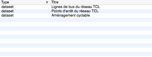
Etape 3 : recherche sur des mots clés (Transport, Bus) et une zone géographique
Requête POST : https://data.grandlyon.com/geonetwork/srv/fre/csw avec dans le data du POST :
<?xml version="1.0" ?>
<csw:GetRecords maxRecords="10" outputFormat="application/xml" outputSchema="http://www.opengis.net/cat/csw/2.0.2" resultType="results" service="CSW" version="2.0.2" xmlns:csw="http://www.opengis.net/cat/csw/2.0.2" xmlns:gml311="http://www.opengis.net/gml" xmlns:ogc="http://www.opengis.net/ogc" xmlns:xsi="http://www.w3.org/2001/XMLSchema-instance" xsi:schemaLocation="http://www.opengis.net/cat/csw/2.0.2 http://schemas.opengis.net/csw/2.0.2/CSW-discovery.xsd">
        <csw:Query typeNames="csw:Record">
                <csw:ElementSetName>full</csw:ElementSetName>
                <csw:Constraint version="1.1.0">
                        <ogc:Filter>
                                <ogc:And>
                                        <ogc:BBOX>
                                                <ogc:PropertyName>ows:BoundingBox</ogc:PropertyName>
                                                <gml311:Envelope>
                                                        <gml311:lowerCorner>4.7027853 45.597999</gml311:lowerCorner>
                                                        <gml311:upperCorner>4.7191596 45.609031</gml311:upperCorner>
                                                </gml311:Envelope>
                                        </ogc:BBOX>
                                        <ogc:PropertyIsLike escapeChar="\" singleChar="_" wildCard="%">
                                                <ogc:PropertyName>csw:AnyText</ogc:PropertyName>
                                                <ogc:Literal>Transport, Bus</ogc:Literal>
                                        </ogc:PropertyIsLike>
                                </ogc:And>
                        </ogc:Filter>
                </csw:Constraint>
        </csw:Query>
</csw:GetRecords>
Exemple de présentation du résultat (plugin CSW dans QGIS) :
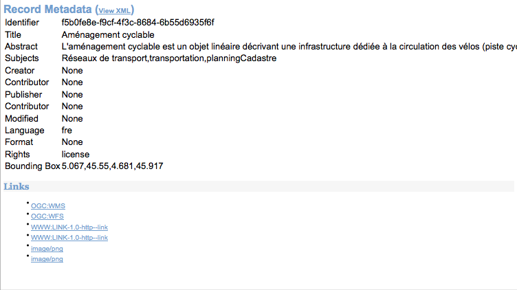
Etape 4 : chargement d’une metadata précise par son ID parmi les résultats obtenus
XML obtenu en retour :
<csw:GetRecordByIdResponse xmlns:csw="http://www.opengis.net/cat/csw/2.0.2">
        <csw:Record xmlns:ows="http://www.opengis.net/ows" xmlns:geonet="http://www.fao.org/geonetwork" xmlns:dc="http://purl.org/dc/elements/1.1/" xmlns:dct="http://purl.org/dc/terms/">
                <dc:identifier>f5b0fe8e-f9cf-4f3c-8684-6b55d6935f6f</dc:identifier>
                <dc:date>2015-11-06T00:06:17</dc:date>
                <dc:title>Aménagement cyclable</dc:title>
                <dc:type>dataset</dc:type>
                <dc:subject>Réseaux de transport</dc:subject>
                <dc:subject>transportation</dc:subject>
                <dc:subject>planningCadastre</dc:subject>
                <dc:format/>
                <dct:abstract>
                L'aménagement cyclable est un objet linéaire décrivant une infrastructure dédiée à la circulation des vélos (piste cyclable, bande cyclable, couloir bus ouverte aux vélos, double-sens cyclable, voie verte, mixité en zone de circulation apaisée). Il est caractérisé par des informations de gestion (nom, description, type d'aménagement, année de réalisation ...)
                </dct:abstract>
                <dc:description>
                L'aménagement cyclable est un objet linéaire décrivant une infrastructure dédiée à la circulation des vélos (piste cyclable, bande cyclable, couloir bus ouverte aux vélos, double-sens cyclable, voie verte, mixité en zone de circulation apaisée). Il est caractérisé par des informations de gestion (nom, description, type d'aménagement, année de réalisation ...)
                </dc:description>
                <dc:rights>license</dc:rights>
                <dc:language>fre</dc:language>
                <dc:source>
                Mise à jour en continu : remontée d'informations travaux des services du Grand Lyon et des partenaires et vérification de la donnée sur le terrain.
                </dc:source>
                <dc:format/>
                <ows:BoundingBox crs="urn:ogc:def:crs:EPSG::RGF93 / CC46 (EPSG:3946)">
                        <ows:LowerCorner>5.067 45.55</ows:LowerCorner>
                        <ows:UpperCorner>4.681 45.917</ows:UpperCorner>
                </ows:BoundingBox>
                <dc:URI protocol="OGC:WMS" name="pvo_patrimoine_voirie.pvoamenagementcyclable" description="Aménagement cyclable(OGC:WMS)">https://download.data.grandlyon.com/wms/grandlyon</dc:URI>
                <dc:URI protocol="OGC:WFS" name="pvo_patrimoine_voirie.pvoamenagementcyclable" description="Aménagement cyclable(OGC:WFS)">https://download.data.grandlyon.com/wfs/grandlyon</dc:URI>
                <dc:URI protocol="WWW:LINK-1.0-http--link" name="pvo_patrimoine_voirie.pvoamenagementcyclable/all.json" description="Description des données dans le format texte JSON">
                https://download.data.grandlyon.com/ws/grandlyon/pvo_patrimoine_voirie.pvoamenagementcyclable/all.json
                </dc:URI>
                <dc:URI protocol="WWW:LINK-1.0-http--link" name="Licence Ouverte" description="Description des conditions d'utilisation de la Licence Ouverte">
                https://download.data.grandlyon.com/files/grandlyon/LicenceOuverte.pdf
                </dc:URI>
                <dc:URI protocol="image/png" name="thumbnail">
                https://download.data.grandlyon.com/catalogue/srv/fre/resources.get?uuid=f5b0fe8e-f9cf-4f3c-8684-6b55d6935f6f&fname=DV_AC_s.png
                </dc:URI>
                <dc:URI protocol="image/png" name="large_thumbnail">
                https://download.data.grandlyon.com/catalogue/srv/fre/resources.get?uuid=f5b0fe8e-f9cf-4f3c-8684-6b55d6935f6f&fname=DV_AC.png
                </dc:URI>
        </csw:Record>
</csw:GetRecordByIdResponse>
Exemple de présentation du résultat (plugin CSW dans QGIS) :